|
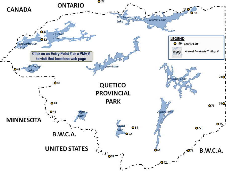
Click on the active areas of the map above, or click a link in the table below.
These official entry points must be used to legally enter Quetico Provincial Park. Quetico is a roadless and unmotorized area operated in a similar manner to the Boundary Waters Canoe Area (BWCA) on the U.S. side of the border. There are regulatory and rules differences though. The main difference is that in Quetico you can camp wherever you want; you don't have to camp at one of the "red dots" on the map. The "red dot" locations usually are the best campsites anyway and you will minimize environmental impact by using them. Most of the entry points into Quetico are along it's edges. However, if entering Quetico from the United States, it is often necessary to cross through the BWCA first. There are 21 entry points for Quetico Provincial Park.
Many of the roads leading up to the entry points are forest roads of packed gravel; some are paved however. The majority of these roads are also dead ends. Once at the entry point, there is often a portage of some sort to move your gear from the parking lot down to the water’s edge. These portages can be trivial to really long. It is possible to visit Quetico on a day permit, although this isn't common since Quetico in general is more difficult to reach than the BWCA. You get day permits from the ranger stations; in the Quetico you must pay for them (they are free for BWCA as of 2017). The permit system is in effect to reduce impact to the wilderness, limit the number of people competing for campsites and to allow for solitude. There are far fewer visitors to Quetico and permits are somewhat more restricted. One last thing, if coming from the U.S., you will also need a Remote Area Border Crossing permit (a RABC as it is known). Check this page for more details.
Entry Points with Overnight Paddle sorted by Name in Quetico Provincial Park
| Entry Point # |
Entry Point Name |
Daily Quota |
Ranger Station Name/# |
Entry Point Details |
Quetico Entry Point Signage |
| 11 |
Baptism Creek |
2 - (2 Canadian, 1 US) |
Dawson Trail (1) |
|
|
| 12 |
Pickerel Lake |
10 (10 Canadian, 3 US) |
Dawson Trail (1) |
|
|
| 21 |
Batchewaung Lake |
7 (7 Canadian, 2 US) |
Atikokan Entry (2) |
|
|
| 22 |
Sue Falls |
3 (3 Canadian, 1 US) |
Atikokan Entry (2) |
|
|
| 23 |
Mack Lake |
3 (3 Canadian, 3 US) |
Atikokan Entry (2) |
|
|
| 31 |
Cirrus Lake |
2 (2 Canadian, 1 US) |
Beaverhouse Lake (3) |
|
|
| 32 |
Quetico Lake |
6 (6 Canadian, 3 US) |
Beaverhouse Lake (3) |
|
|
| 41 |
Threemile Lake |
2 (2 Canadian, 2 US) |
Lac La Croix (4) |
|
|
| 42 |
Maligne River |
2 (2 Canadian, 2 US) |
Lac La Croix (4) |
|
|
| 43 |
McAree Lake |
2 (2 Canadian, 2 US) |
Lac La Croix (4) |
|
|
| 44 |
Bottle River |
2 (2 Canadian, 1 US) |
Lac La Croix (4) |
|
|
| 51 |
Basswood River |
2 (2 Canadian, 2 US) |
Prairie Portage (5 & 6) |
|
|
| 52 |
Sarah Lake |
2 (2 Canadian, 2 US) |
Prairie Portage (5 & 6) |
|
|
| 53 |
Kahshahpiwi Lake |
2 (2 Canadian, 2 US) |
Prairie Portage (5 & 6) |
|
|
| 61 |
Agnes Lake |
7 (7 Canadian, 7 US) |
Prairie Portage (5 & 6) |
|
|
| 62 |
Carp Lake |
2 (2 Canadian, 2 US) |
Prairie Portage (5 & 6) |
|
|
| 71 |
Knife Lake |
2 (2 Canadian, 2 US) |
Cache Bay on Saganaga Lake (7) |
|
|
| 72 |
Man Chain of Lakes |
2 (2 Canadian, 2 US) |
Cache Bay on Saganaga Lake (7) |
|
|
| 73 |
Falls Chain of Lakes |
2 (2 Canadian, 2 US) |
Cache Bay on Saganaga Lake (7) |
|
|
| 74 |
Saganagons Lake (Boundary Point) |
2 (2 Canadian, 2 US) |
Cache Bay on Saganaga Lake (7) |
|
|
| 75 |
Fly In Only (Cache Bay, Saganaga Lake) |
1 (1 Canadian, 0 US) |
Fly In |
|
|
Note that permit quotas are sometimes revised (permanently or temporarily) depending on conditions in Quetico Provincial Park.
|

