BRULE LAKE CAMPSITES: Campsite 1 (#940): On point just northeast of BWCA Entry Point 41 landing. Campsite 2 (#939): On south side of island 0.6 miles northeast of BWCA Entry Point 41 landing. Campsite 3 (#937): West shoreline of North Bay Campsite 4 (#935): Northeeast corner of North Bay Campsite 5 (#938): On north side of island in North Bay Campsite 6 (#945): First campsite along the south shoreline west of the BWCA Entry Point 41 landing Campsite 7 (#953): On the west end of a large island, almost due north of BWCA Entry Point 41 landing Campsite 8 (#941): On the northeast tip of large island, nearly due north of BWCA Entry Point 41 landing Campsite 9 (#942): On the west end of an island just southeast of the entrance to Lily Bay (where the portage to Lily Lake is located) Campsite 10 (#944): On the east side of the entrance to Lily Bay (where the portage to Lily Lake is located) Campsite 11 (#948): In Cone Bay, across channel from start of the South Cone Lake portage Campsite 12 (#934): In Cone Bay, along the northeast shoreline Campsite 13 (#936): On north shore of Brule Lake, second campsite east of Cone Bay, near the back of a narrow bay
Campsite 14 (#946): West end of Jock Mock Bay
Campsite 15 (#947): On the north shoreline of Jock Mock Bay
Campsite 16 (#955): First campsite east of the South Temperance Lake portage along the south shoreline
Campsite 17 (#957): On the island just southeast of the South Temperance Lake portage
Campsite 18 (#956): On west side of large island due south of the long bay extending north to the Cam Lake portage
Campsite 19 (#949): Southwest corner of Cone Bay
Campsite 20 (#950): Just southwest of Cone Bay
Campsite 21 (#954): On island in main part of lake not far south of Cone Bay
Campsite 22 (#967): At the east end of the large island that is northeast of the BWCA Entry Point 41 landing
Campsite 23 (#951): Located on the east end of Brule Island
Campsite 24 (#971): On the north shoreline, just northeast of Brule Island
Campsite 25 (#970): On the point on the west side of Brule Bay
Campsite 26 (#969): On the north shore of Brule Bay
Campsite 27 (#972): On the east end of Brule Bay
Campsite 28 (#968): On the south side of Brule Bay
This is the second largest lake that is entirely within the Boundary Waters Canoe Area (BWCA). Only Trout Lake in the western part of the BWCA is larger. Brule Lake is the largest lake in the BWCA that is non-motorized. Trout Lake allows motors. This is not a good lake to cross on a day with strong winds. The lakes shoreline is nearly 38 miles long. The Lake is located in the Duluth Complex, a geological formation that underlies much of the BWCA. Brule Lake lies in a valley about 600 feet deep between two sills formed from the rocks of this complex. North of Brule Lake lie the Misquah Hills, to the south is the sill containing Brule Mountain whose summit is just 0.6 miles south of BWCA Entry Point 41.
The name of the lake is derived from the French word meaning "burnt wood".
Brule Lake offers many route opportunities, with a total of six portages leading out of the lake into other parts of the BWCA. There are also over 30 campsites located on Brule Lake, so even late starters will be able to easily find a place for the night. Note that BWCA Entry Point 40 - Homer Lake is just 1 1/2 miles down the road from the Brule Lake entry point. You'll pass it coming in. So a nice short route is to travel between these two entry points.
There are two entry points for Brule Lake (#41 and #42). Entry point 41 has no restrictions. If you use BWCA Entry Point 42, you must camp on Brule Lake for the duration of your BWCA visit. You may travel to other lakes though during the day.
Logging impacted the area here in the 1920's and early 1930's. In 1918, the Northern Logging Company purchased the Alger Smith line to access the timber near Brule Lake. A large logging camp was located along the south shore of Brule Lake. The modern day entry point area was the location of a log hoist. Several smaller logging camps existed along the north shoreline. This was the Brule Lake General Logging Company. Fires around Brule Lake in 1929 brought an early end to the logging operations. The 1929 fire, which started near Star Lake on July 22, was probably caused by sparks from railroad cars used to haul the logs. This was a slash fire (a fire that burns forest that was recently logged). The clearing of trees allows the forest floor to dry out quickly, making fires more likely (Heinselman, 1999). This fire burned the forest along the shorelines of Brule Lake, Homer Lake and Juno Lake. The fire consumed about 25,000 acres. The fire was out by August 7, 1929 (Hansen, 2007). A number of other fires burned in 1929 as detailed in Heinselman.
A fire of about 4,450 acres started on June 14, 1996 as a result of a lightning strike. This fire burned from the eastern side of South Temperance Lake toward the southeast. The fire spread along the southwestern corner of Brule Lake, to the west end of Juno Lake and portions of Vern Lake and the Vern River. The fire was mostly out by the end of the month (Hansen, 2007). The fire cost and estimated $1.5 million (Beymer, 2006).
The remains of possibly a dock are still visible at the Lily Lake portage landing as of 2022. This structure was perhaps used for logging and/or resort boat traffic that operated on this lake in the past.
Another logging operation was run north of Brule Lake beginning1944 and ending in 1950. The remains of possibly a dock of some sort are still visible at the Lily Lake portage landing as of 2022. This structure may have been built as part of the North Star Company logging operations. This company, a subsidiary of the Kimberly-Clark Corporation, harvested mostly pulpwood from the area north of Brule Lake. They used trucks to haul this material out of the woods and the Lily Lake portage was along one of those routes to Brule Lake. All of their operations were conducted in the winter over ice roads. The winter roads ended at the General Logging Company railroad on Brule Lake (Heinselman).
The final logging sale on Brule Lake was called the East Tofte Sale and it occurred in 1961 (Heinselman). This last round of logging wasn't for big timber, but rather for pulp. This operation was short-lived however, as on September 3, 1964, President Johnson signed The Wilderness Act. This Act included the BWCA. Logging operations ceased soon afterwards.
There were a couple of resorts and a bait store near the landing on Brule Lake. The Pure Oil Company had a company retreat on the largest island on Brule Lake which
was later sold to Ruan, a truck rental company. These businesses closed around the World War II era.
Brule Island contained at least five small structures (cabins, a few small outbuildings and a home that did double duty as a small lodge for customers) that were still standing at least into the 1960's. The camp on this island was run by a doctor from Illinois. The back of Jock Mock Bay (west shoreline) also had a few structures along the shoreline, again at least into the 1960's.
Sky Blue Water Resort was the last resort on Brule Lake. Located in a bay along south side of lake. It closed down in 1986. Once it closed the 1978 BWCA Wilderness Bill took effect and motor usage was banned on Brule Lake.
Brule Lake is the source of both the Temperance River, which flows out the western end of the lake, and the South Brule River, which flows out the east end of the lake.
There used to be a crude statue on the tiny rocky island just north of the island on which BWCA Campsite 952 is located.
Click on the photos below to see the full resolution image - Use your browsers back button to close photo and return to this page.
PADDLING FROM BWCA ENTRY POINT 41 TO BWCA CAMPSITE 940
For late arrivals, take this short paddle to the nearest campsite to the entry point landing. The campsite is so close to the landing, you will likely hear occassional vehicle noises and loud visitors.
Visit Campsite 940 -or- Explore Another Route ***********************************************END OF ROUTE***********************************************
PADDLING FROM BWCA ENTRY POINT 41 TO BWCA CAMPSITE 953
After backing away from the entry point landing, head north and paddle about two-thirds of a mile to this island campsite. Visit Campsite 953 -or- Explore Another Route ***********************************************END OF ROUTE***********************************************
PADDLING FROM BWCA CAMPSITE 953 TO BWCA CAMPSITE 941
Paddle from this island campsite to the island campsite located just to the northwest across the channel. The campsite is on the northeast point of the island. The entire distance is about 0.25-miles. Visit Campsite 941 -or- Explore Another Route ***********************************************END OF ROUTE***********************************************
PADDLING FROM BWCA CAMPSITE 941 TO BWCA CAMPSITE 942
Head from this island to the next island to the north on Brule Lake. On the west end of that island is BWCA Campsite 942. Visit Campsite 942 -or- Explore Another Route ***********************************************END OF ROUTE***********************************************
PADDLING FROM BWCA CAMPSITE 942 TO BWCA CAMPSITE 944
Brief paddle to the northwest to the next campsite, which is located on the east side of the entrance to the bay where the Lily Lake portage is located. Visit Campsite 944 -or- Explore Another Route ***********************************************END OF ROUTE***********************************************
PADDLING FROM BWCA CAMPSITE 944 TO THE LILY LAKE PORTAGE
Paddle from the entrance to Lily Bay northbound along the eastern shoreline to the Lily Lake portage. The portage is located at the very north end of the bay. Portage to Lily Lake -or- Explore Another Route ***********************************************END OF ROUTE***********************************************
PADDLING FROM BWCA CAMPSITE 940 TO BWCA CAMPSITE 939 LOCATED ON AN ISLAND
If you find the campsite on the point occupied, it's a short paddle over to this island campsite. This site is on the west end of a rather large island, along its south shoreline.
Visit Campsite 939 -or- Explore Another Route ***********************************************END OF ROUTE***********************************************
PADDLING FROM BWCA CAMPSITE 939 TO THE ECHO LAKE PORTAGE
Heading east from the campsite, meander through the channel formed by the island the the Brule Lake shoreline to the south. On the east tip of the island, you paddle past BWCA Campsite 967. From there, continue east along the south shore of the lake for about half a mile. At that point, turn north and cut across the lake and start heading west, now along the north shore of the lake. Continue along the westerly course, eventually turning north to arrive at the Echo Lake portage landing just south of the east channel entrance to North Bay. Portage to Echo Lake -or- Explore Another Route ***********************************************END OF ROUTE***********************************************
PADDLING FROM THE ECHO LAKE PORTAGE TO BWCA CAMPSITE 937 IN NORTH BAY
Paddling from the Echo Lake portage to the eastern entrance to North Bay on the north side of Brule Lake.
Continuation of the travel from the Echo Lake portage to BWCA Campsite 937. Here you are traveling from the east channel entrance of North Bay over to the west side of the bay. Here you will find BWCA Campsite 937 tucked amongst heavy tree cover. Visit BWCA Campsite 937 -or- Explore Another Route ***********************************************END OF ROUTE***********************************************
PADDLING NORTH BAY FROM BWCA CAMPSITE 937 TO BWCA CAMPSITE 935
Paddle east across North Bay to this rather sparse campsite on the east side of the bay. Visit BWCA Campsite 935 -or- Explore Another Route ***********************************************END OF ROUTE***********************************************
PADDLING NORTH BAY FROM BWCA CAMPSITE 935 TO BWCA CAMPSITE 938
Brief paddle between these two campsites in North Bay.
Visit BWCA Campsite 938 -or- Explore Another Route ***********************************************END OF ROUTE***********************************************
PADDLING FROM BWCA CAMPSITE 938 IN NORTH BAY TO THE LILY LAKE PORTAGE
After leaving the campsite, paddle west following the north side of the island that makes up the south boundary of North Bay. Head out the west channel into the main part of Brule Lake, hugging the north shoreline. You pass south of the peninsula that separates North Bay from the bay that provides access to the Lily Lake portage. The peninsula is capped with a steep side hill that rises to 2014 feet above sea level. This is 180 feet above the surface of Brule Lake. BWCA Campsite 944 is on your right as you round the peninsula and turn north into the bay. You reach the portage to Lily Lake at the north end of this pay. Portage to Lily Lake -or- Explore Another Route ***********************************************END OF ROUTE***********************************************
PADDLING FROM THE LILY LAKE PORTAGE TO BWCA ENTRY POINT 41
This is a long paddle from the north side of Brule Lake to the south side of the lake, eventually culminating at the BWCA Entry Point 41 landing. The track is mostly due south, passing between several islands and passing a few campsites. The first campsite you pass is BWCA Campsite 942 on the west end of a thin island. Next you pass to the east of BWCA Campsite 941, which is located on the east point of sizeable island to the northwest of the entry point. Lastly, you paddle by BWCA Campsite 953 (and are chased off by barking dogs). From that last campsite, you head for the parking lot.
Explore BWCA Entry Point 41 -or- Explore Another Route ***********************************************END OF ROUTE***********************************************
PADDLING FROM THE CAM LAKE PORTAGE TO THE TEMPERANCE RIVER PORTAGE
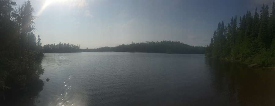
This paddle across Brule Lake takes you south from the Cam Lake portage and then west over to the Temperance River portage and the beginning of that river. As you paddle, to your right are two very prominent hills that are visible for much of the route through Brule Lake. These hills rise to over 2,000 feet above sea level. For reference and comparison, the highest point in Minnesota is 2,301 feet (Eagle Mountain). Here is a list of the highest points in the BWCA and in Minnesota.
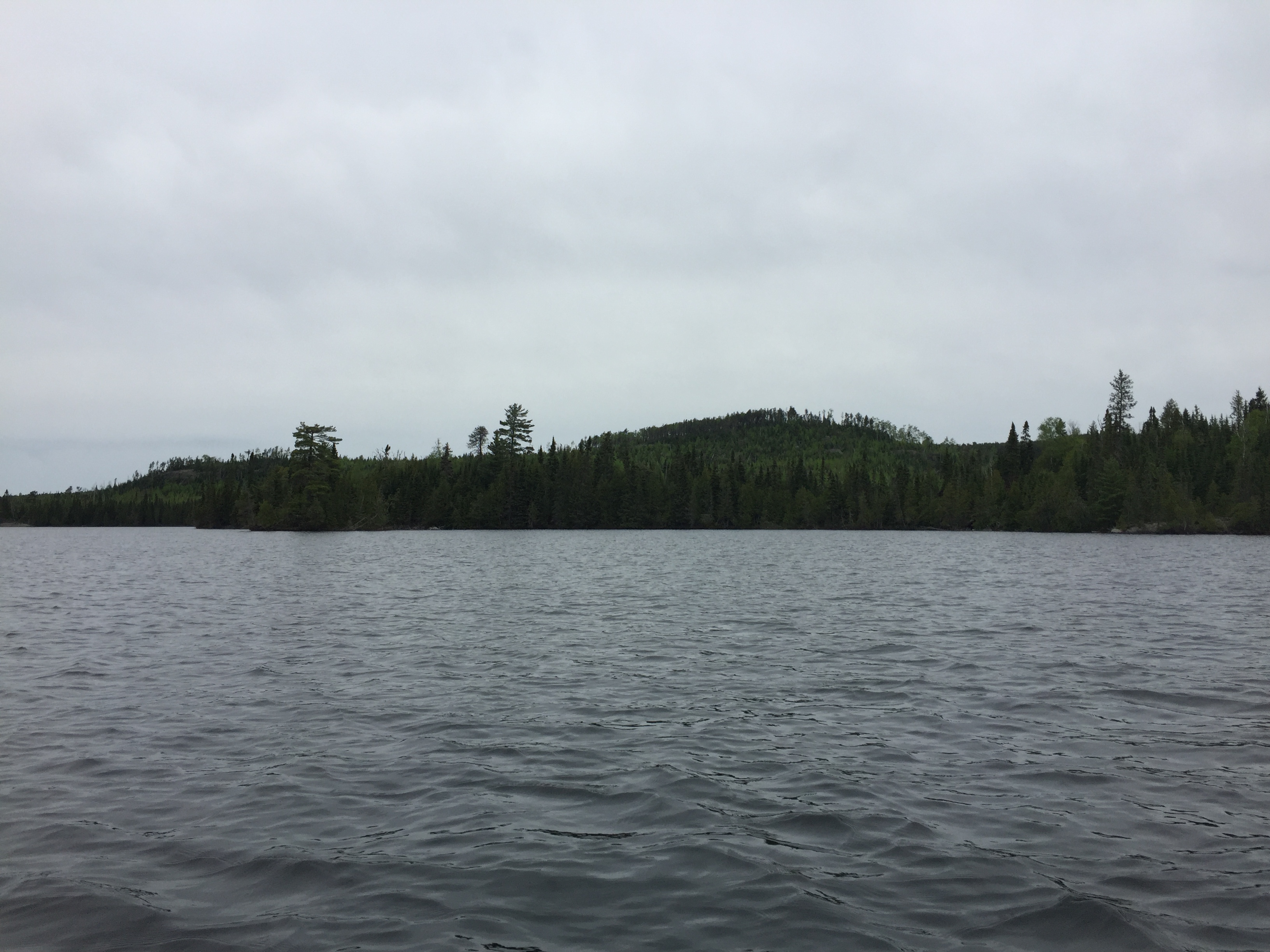
Brule Lake from the Cam Lake portage. The lower slopes of the large hill just south of Wench Lake is visible in the center distance. This hill is 2,060+ feet in elevation. The surface of Brule Lake is 1,834 feet.
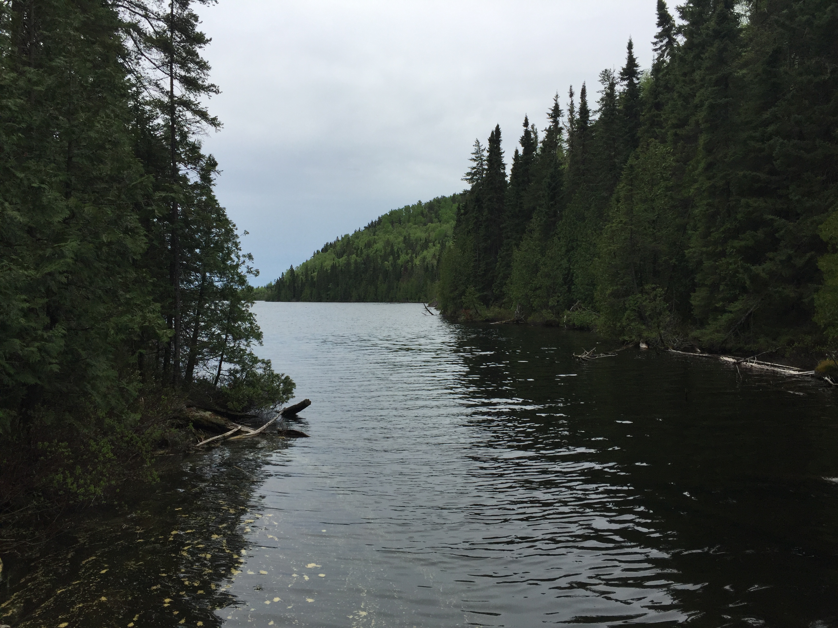
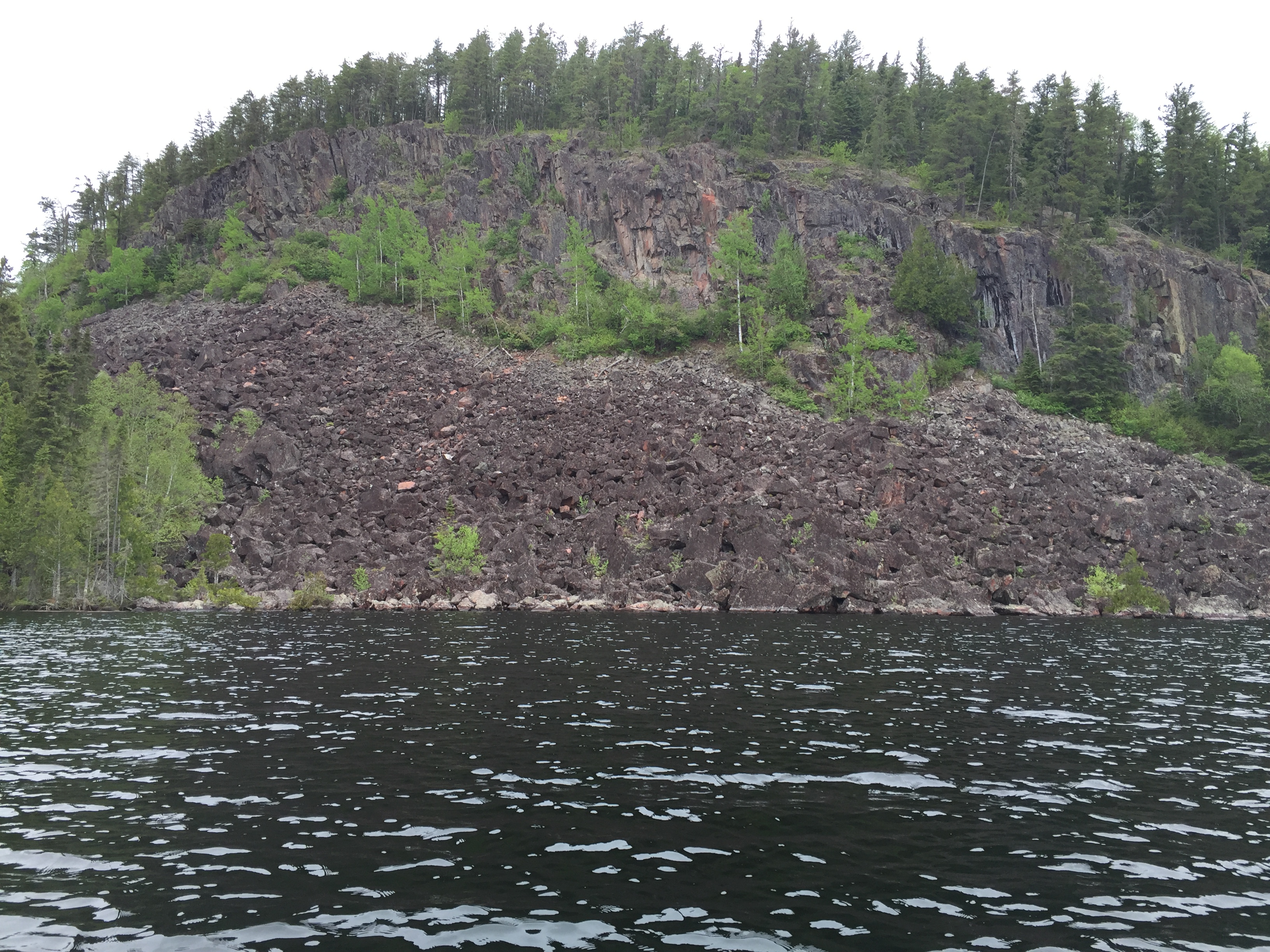
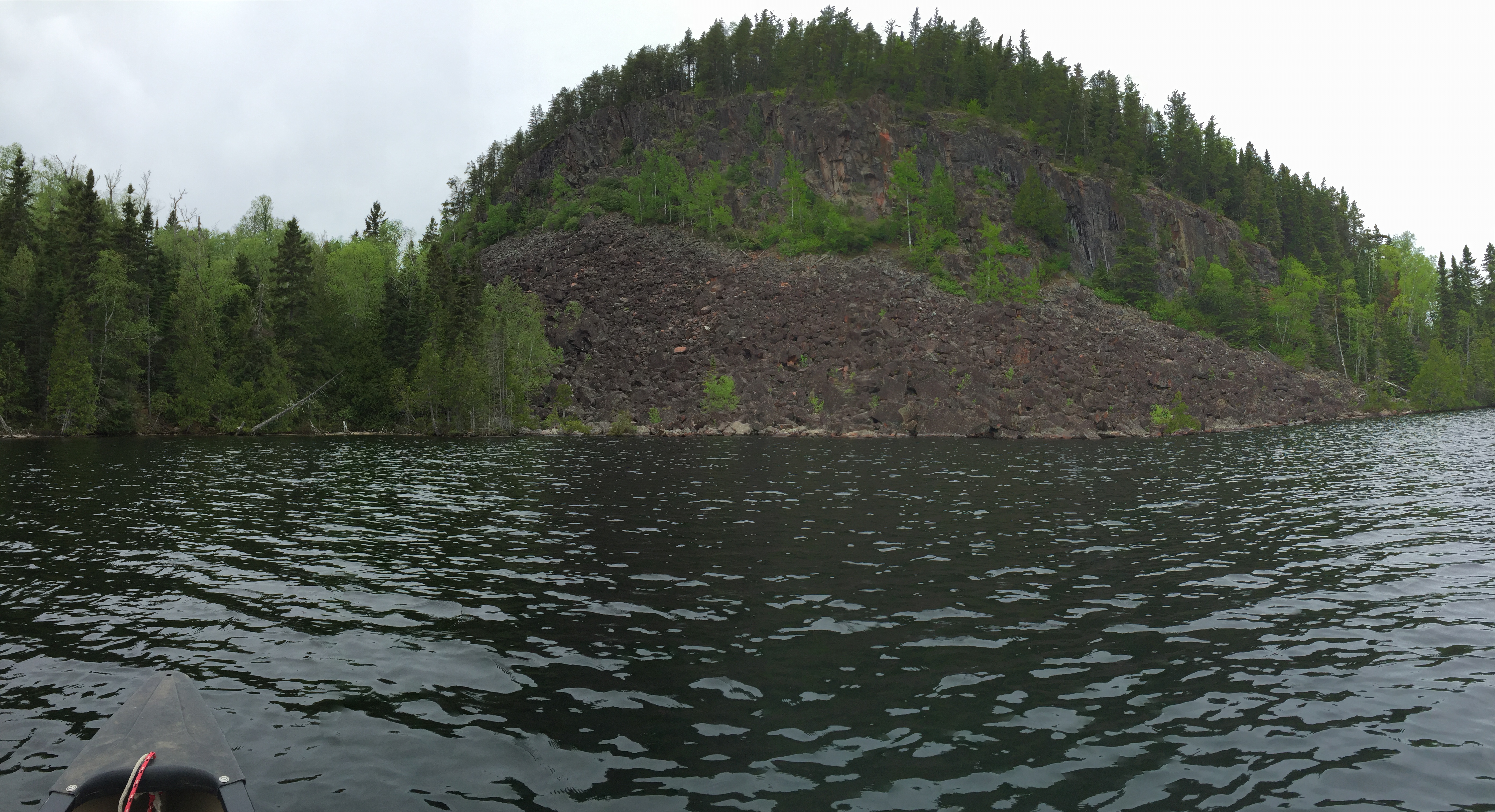
From the Cam Lake portage, begin by paddling south down the northwest bay of Brule Lake. After coming out of the bay, you round a point with a large talus debris field below of high cliff on the west shoreline. This is similar to another talus field on nearby Gasket Lake. Another short stretch of paddling toward the south takes you to the mouth of this bay, which is located in the northwest part of Brule Lake. Once through the mouth of the bay, you continue paddling due south to another channel. After passing through this channel you are greeted by many islands in front of you. From the channel you steer to the west, now heading directly for the Temperance River portage. The Temperance River portage is located behind a small island. You can pull up on a smooth rock slab on your right, just as you enter the Temperance River. Some rapids are just beyond, so don't continue.
The point on the west side of the bay that leads to the Cam Lake portage. This is just southeast of the east end of Wench Lake. A large talus slope has been created over geological time at the base of the cliff.
Another view of the cliff from a bit further out on the lake. The channel leading to the bay where the Cam Lake portage is found is just to the right out of the view.
A more distant hill as seen from about a quarter-mile east of the Temperance River portage. This more distance hill lies just northwest of Wench Lake. It has a measured elevation of 2,151 feet and is about three-quarters of a mile away from where you float in your canoe.
The island just offshore to the east of the portage into the Temperance River. The Temperance River's headwaters are here at Brule Lake. The Temperance River begins just out of view over your right shoulder. Portage to the Temperance River -or- Explore Another Route ***********************************************END OF ROUTE***********************************************
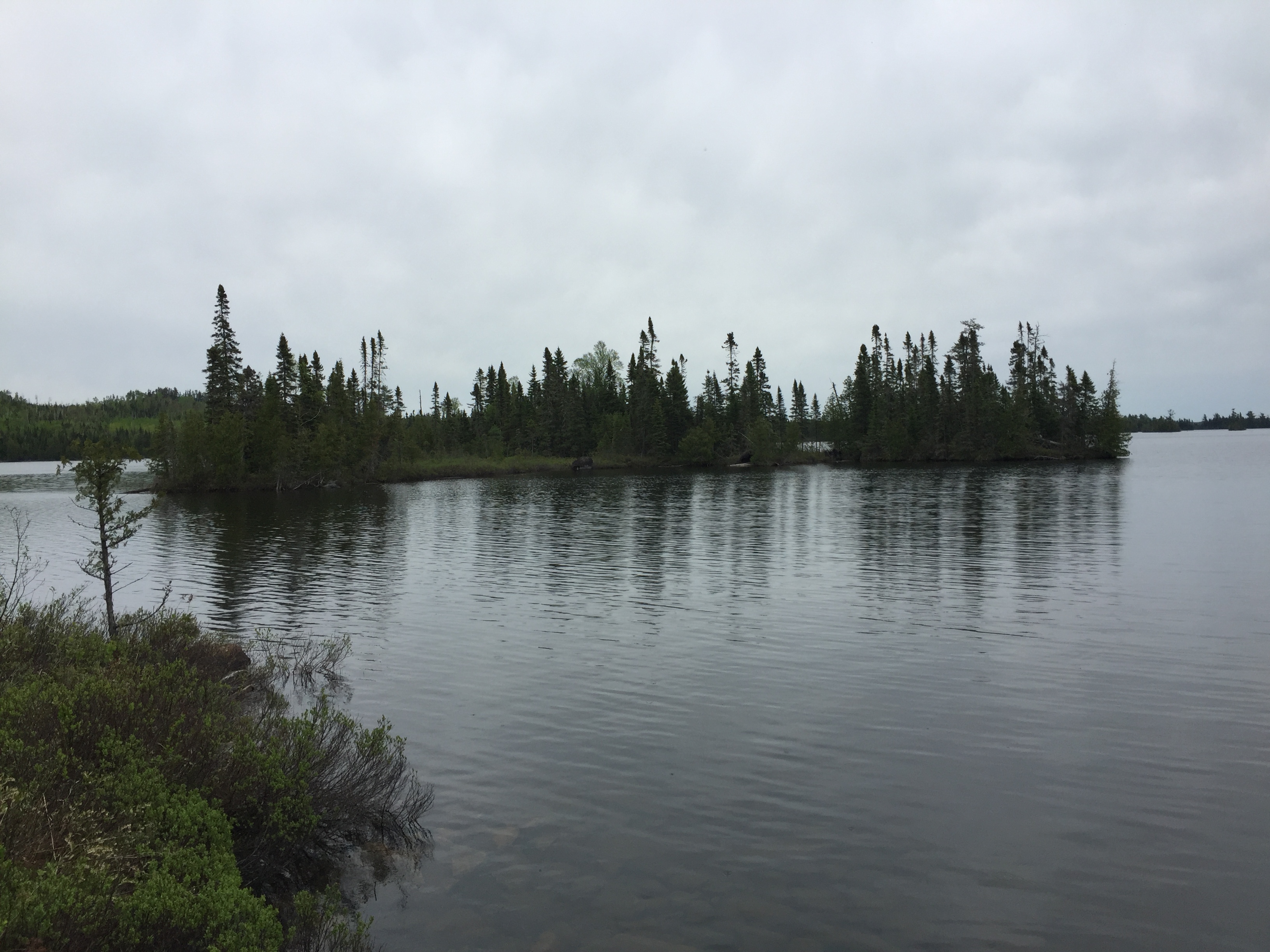
VIEW OF BRULE LAKE FROM BWCA ENTRY POINT 41
Brule Lake from the BWCA Entry Point 41 landing. (Image not expandable)
From Brule Lake, you can portage to Cam Lake, Echo Lake, Juno Lake, Lily Lake, South Cone Lake, South Temperance Lake (after passing through a short section of the Temperance River) or Vernon Lake. There is also a steep portage up to Wench Lake, which isn't shown on many maps. If it's more adventure that you seek, you can also potentially bushwhack to Bull Lake (there was once a maintained portage to this lake), Cow Lake and Headlight Lake. Also, Brule Lake is the location of BWCA Entry Point 41 - Brule Lake.